Tag Archives: urban planning

Sport and Planning: What is the right number of school sports pitches?

On Tuesday, the Guardian ran a breathless article about the state of playing fields in America, prompted by a recent vogue in the UK for selling school sports fields.  The article describes a “typical” high school in suburban New Jersey with ten sports fields (including a marching band practice field) in addition to an indoor sports complex.  It also describes 60,000-person capacity stadiums with press boxes, and tops it off with quotes about high school athletes’ dedication (and attendant burnout and injuries).  The article states as gospel the following: that no school would ever sell its sports fields (true); that all schools have acres and acres of land given over to pitches (false).  Finally, it declines to address the ramifications of default sports fields, which aren’t great.

The comments, I should note, are vitriolic and hilarious, and the article is a response to a real, and unfortunate, phenomenon of schools (particularly in deprived areas) selling fields to finance school running costs.  But I want to address my issues with the article in the order I listed them above:

First: in the US, selling off sports fields really is unthinkable (although developing more academic buildings on them isn’t).  The reason isn’t Americans’ passionate love of sport; rather, its because schools are funded at the municipal level (in the UK, most services are controlled by the county).  For English readers: I grew up in a town of 14,000 people in Wisconsin.  The residents of the town paid taxes that funded two primary schools and one high school.  The school was a community asset that was paid for by the residents of the town in a much more visceral way than in the UK, where schools are administered at the county level.

Second: many schools do not have double-digit sports fields.  As a case study, my suburban school (student body ~500) has won ten state championships in various sports over the last decade.  It has two sports fields that it shares with the middle school. I’ve included the entire campus and some adjacent development, for context, in the image below:


All images in this post courtesy Google maps.

The nearest high school to the north has three, one of which is also a public park. The school to the south has two.  All of them are available for community use during the day and in the evening.  A friend of mine went to a very expensive private school in New York; their sports teams played and practiced in a public park.  The notion that huge swaths of urban areas are given over to high school sports is just untrue.

It is true that many schools built in the last forty years have been built on greenfield sites on the periphery of urban areas with expansive fields: the school below was completed in 2000, and was built with five baseball fields and three football/soccer pitches.  It was also built on a site that had formerly been a cornfield on the edge of town.
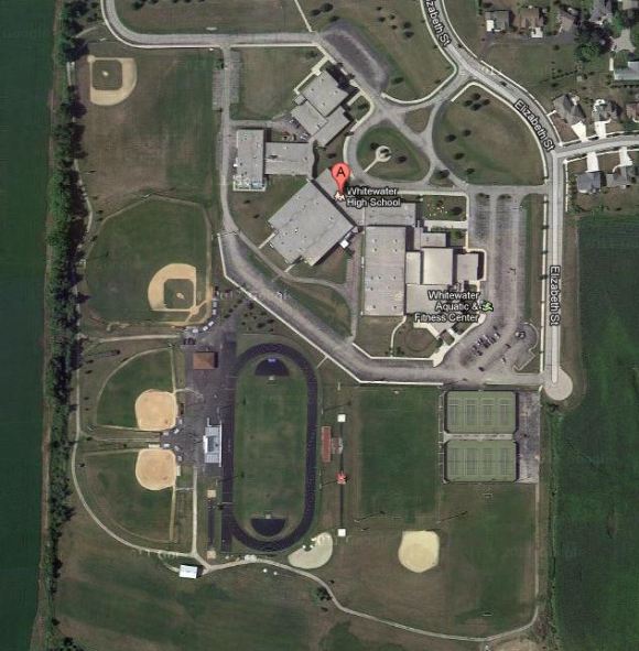
That, I think, is a really lamentable angle that the author of the Guardian article failed to mention: my high school is in the middle of a town, part of a larger urban area and easily available to community members who want to take advantage of the sports facilities.  The school above, despite being built into a cornfield, is immediately adjacent to a small town – I know about it because I was a summer tennis coach on the courts shown in the photo for a couple summers in college.  Franklin High School, the Guardian’s “typical” school, is in the middle of nowhere:

It sure does have a lot of sports fields, but they don’t serve the community. The school is built in the exurbs of New Brunswick, New Jersey – it could  just as easily have been built a few miles to the east, where there’s a big chunk of land immediately adjacent to the public library.  If ever there was a logical place to put a school, its on the empty land right next to the library.  Some students might even have been able to walk to school.

In other words: the ample sports pitches of American suburban schools actually hint not so much at the way Americans value fitness, but at the way they don’t, and at the way that planning decisions are perpetuating sprawl.  There is a feeling that new school buildings should have ample outdoor space, but that space comes at a cost that the Guardian article didn’t address.  I don’t think the schools should sell their sports pitches, but I wish the school had been located in a place where it might ever, in a million years, make any kind of financial sense to think about doing so.


Tagged , , , ,

Impressions of Tibby’s Triangle, Southwold

Last month, my friend Jaime visited from Israel and I had five days to give her a peek into my exciting (not so exciting) UK life.  Jaime and I met in planning school, so I particularly wanted to take her to see a really cute, quintessential British seaside town.  We settled on Southwold for 2 main reasons: 1, there is a new Ash Sakula housing development there that I wanted to see and 2, Adnam’s Brewery is there.  Holler!

The scheme, as you’ll see from the movie, is a small development – 26 houses – just off the main drag in Southwold, near a cemetery, a playground, the beach, and a whole bunch of super cute seaside-y houses.  It was built on some land owned by Adnam’s, and the architects also designed an adjacent pavilion, cafe, and shop owned by Adnam’s.

For the most part, I really liked the development.  In the video, the architects talk about trying to mimic Suffolk vernacular (which is something I’ve heard a lot about, in design reviews in Suffolk).  They tried to do that by using referential materials, incorporating lots of small-scale cut-throughs, and including small-scale green spaces into the development.  All the houses have access to some outdoor space, which is nice, and (as promised in the video) none of the building heights are the same.  There’s also a flatiron building in the middle of the development that I think is particularly cute.

The  image above shows some of the pros and cons of the scheme.  The pros I think I’ve already established: its cute, it clearly takes Suffolk as its inspiration, its visually interesting, its porous.  All good stuff.   The pros outweigh the cons, but there were two things that I really, really noticed that I would have done differently: first, as you can see from the image above, the space to the left of the flatiron building is devoted to cars.  Every house has its own space, which I understand it necessary from a real-estate perspective.  The amount of asphalt may have been a requirement for fire truck turning radii or something – but the edges of the development have a fine-grain, intimate feel; its weird that the middle of the thing is basically a parking lot.

The other complaint I have is with one of the housing styles (despite the variety, there were three or four house themes and palettes that were repeated throughout the development):


This is where I think the commitment to vernacular references broke down.  But I don’t object to this house (there were several of them) because they’re modern; I object to them because they’re ugly. I think the windows are awkwardly set into a boring facade.  The thing that I really hate, though, are these semi-enclosed parking spaces. I think they are the worst sort of faux-modernism; I think they destroy the intimate pedestrian feel that the architects worked so hard to cultivate in the rest of the project, and I think they aren’t even that useful – there’s no storage; there’s no extra living space; the half-garage has a larger surface area than two surface parking spots – its just stupid.  It made me angry.

I think at heart my biggest objection to the scheme – which I did find quite lovely – is that the architects smushed together the car space and pedestrian space without really reconciling the two.  The alleys through the little neighborhood are dominated by pedestrians, but (especially around the flatiron building), people on foot feel like interlopers – a feeling reinforced by the architecture, planning and landscaping across the site.

Tagged , , , , , ,

Making use of Highway Dead Space

In  many cities, highways cut the city up, acting as barriers between neighbourhoods.  They block off parkland and waterfront from easy pedestrian access.  Urban highways aren’t going away any time soon, but cities are making strides to work around overpasses (or below, in this case).

Toronto just opened Underpass Park as part of an overall revitalization of Toronto’s Waterfront, and in preparation for Toronto’s hosting of the 2015 PanAm games.  It includes a playground for children, basketball courts, and (I think best of all) a skate park.  Development has yet to be completed around the park, leaving it sort of isolated for now.  But it’s great to see the city taking innovative steps forward, and thinking about what will get people into this park – what will get people using this park.  And I think the skate park is a great way to do that – and it’s a great sign we’ve stopped be so scared of skateboards in the city.

Tagged , , , , , , , ,

Vauban, A Planner’s Dream

On a recent trip to Switzerland, I took an overnight trip to Freiburg, where I was able to spend a couple hours wandering around Vauban, a  one-square-mile eco-village built in 2006.  The city has been lauded as the best low-carbon living in Europe; cars are generally excluded from the development altogether (there are garages on the periphery); a tram runs through the middle of the development; and freestanding houses are forbidden.  One hundred of the homes in the development meet Passivhaus energy standards, and, as I walked around, I lost count of the number of green roofs and solar panels within minutes.  They’re everywhere.

Vauban is one square mile.  Houses are four or five stories tall.  The development is mixed-use, with a (delightful) cafe, a grocery store, some small-scale retail, and roughly a bazillion playgrounds, schools and other facilities for children and families (and for me.  Because I climbed all over the playgrounds, and it was awesome). In general, the design quality of all of the buildings is really high, and in proportion and design, it called to mind a very modern Back Bay.  The houses where of uniform proportion and design without being monotonous; the streets were narrow but not claustrophobic; and the whole place felt prosperous and well-heeled.  We wandered around for hours, commenting continuously about how everything should be designed like Vauban.

The development was originally Nazi army barracks that were occupied by the French.  Some of the buildings were turned into student housing for the University of Freiburg; some were retrofitted and turned into apartment buildings.  Many were leveled to make room for new housing and mixed-use buildings on the one-square mile site.  There were no streets in the barracks, so the site already had a human-scale development pattern that the urban planners maintained and improved upon.

The whole place felt pretty amazing.  Freiburg was recently named one of the best places to live in Germany, and we were there on a day that was pretty much perfect. There were children all over the place, and the development was quiet (no cars) but full of life.  The thing that struck me the most is how green it was.  There were green roofs, trees, shrubs, allotment gardens – it felt like a place that had been tended for generations rather than a place called forth from the minds of urban planners less than a decade ago.  I was also struck by how successful the car-free streets were.  The last car-free city I was in, Louvain La Neuve (in Belgium, in February) felt creepy and out of scale – a little like the empty cities in Inception.  Not so with the Vauban.

All rhapsodizing aside, though, I have a few major critiques of the development. The first is a question of density – 6500 people live in the square mile.  That’s not that many. Cambridge, MA has an average density of 7,350ish.  Cambridge, UK has 7600ish.  And Shorewood, WI – my hometown – has a population density of 8600ish.  You’d think that eliminating all those streets would give the developers plenty of space for more people than a streetcar suburb in the American Midwest, and that such density, in the absence of cars, would be desirable.  I found the number to be disappointing.

The other thing that I found really jarring was the tramline/Main Street down the middle of the development.  The tramline was built in concert with the development (good!) and the tracks are covered with grass, a design detail that I admired throughout Germany and Switzerland.  But the street was huge, treeless, and lacking in any activating features (most of the houses turned away from the street).  Furthermore, since most of the houses are carless, there was hardly any traffic on the massive central road.  The tramline/main street was as divisive as a river, and substantially less scenic.

Finally, while there was certainly plenty of mixed-use development, there didn’t seem to be any commercial center per se, or any Main Street (at least that I found).  We found a few businesses, and we stopped at the grocery store on the edge of the development and bought goo-gobs of Ritter Sport chocolate, but the cafe where we ate lunch was on an edge of development and was set far back from the walking path.  It had a lovely terrace and some pretty old trees, but very little adjacent commercial space.  It was the only commercial development that we saw on that side of the tramline/main street, and seemed like pretty slim pickings for 6500 people to share.

Despite my reservations, though, I would be thrilled to live in a place like that, and I fervently hope it inspires copycats (and that they read my blog and eliminate the enormous main street).

Tagged , , , , , , ,

King’s Cross = Awesome

I was in London last week, and I got to see the new King’s Cross station just a few days after opening.  I’d seen renderings, and this was a rare occasion when the real thing was everything promise by the drawing and more.  While its not The Platonic Public Space, its an enormous improvement on what was there before, and I think it really makes a huge difference to the area.

King’s Cross and environs is currently undergoing a huge, decade-long revamp, and this development is on the vanguard of completed projects.  I was traveling through King’s Cross a lot in the fall, so I can say with authority that this new public space – including a new retail gallery, a ticket office, a huge covered corridor and Underground connection – is a fantastic addition to the area.

Furthermore, I was there just a few days after the official opening, and there was still a large-scale public information campaign to retrain the public how to use the station.  On the one hand, I think traffic patterns should be clear if the space is well-designed.  On the other hand, thousands of people have used the station the way it was for the past however many years, and I did actually profit from a woman wearing a sandwich board (in the same finger-pointing shape as above) directing me from the Tube to the station.  The public information campaign has been really well executed.

I should also say that, while I am certainly a nerd for stopping to take pictures, I was hardly the only one doing it.  The space isn’t perfect, but the effect is really impressive.  It actually stopped me in my tracks as I rounded the corner from platform 9.

Tagged , , , , , , ,

The National Planning Policy Framework

Wordle courtesy vsnw.co.uk.

The new UK national planning document, the National Planning Policy Framework, was officially released today.  I haven’t had a chance to see how many changes were made from the draft version (which has been kicking around for months); the blogosphere was fairly quiet about it today (although the internet has had plenty to say about the NPPF over the last year or so).  The best resource so far is this article from the Telegraph.

The idea behind the document is that it replaces thousands of pages of documents generated over the course of decades with a single go-to policy “in favor of sustainable development.”  The NPPF has cheerleaders and detractors.  As I read it, the central tenets of the document aren’t fundamentally bad, but (as one might expect, when 50 pages distills 1000s), its capable of being interpreted about a bazillion ways: sustainable is never defined, for example.  What constitutes sustainability? I could give you my definition, but somehow I doubt it corresponds to what the conservative politicians had in mind when they drafted it. It is also hazy on things like density, urbanity, provision of affordable housing, and conservation of green belts around towns, among other things.  These aren’t niggling details.  They are critically important to envisioning the future of England as dictated by the NPPF.

If I were to provide the glossary for the document, I think it might be pretty strong.  But since no one’s asked me to yet, I think the definitions will be hashed out over time.  It will be sloppy and yield some unfortunate planning results.  But the planning system as it has historically existed isn’t streamlined or efficient, and leaves much to professional judgment.  Basically I think the former planning system was the lesser of two evils.

Those of you outside the UK are probably unaware, but whether good or bad, its a huge shift in the way the country approached planning and could have real implications for the way England builds in the coming decades.

Tagged , , , ,

Matthew Yglesias: Professional Smartypants

Matthew Yglesias is a former blogging wunderkind (that was, like, five years ago.  Now he’s just a blogger for Slate, albeit a really good one) who has just released an e-book entitled “The Rent is Too Damn High,” a reference to a New York political party of the same name.  In an interview with the New York Time’s Economix blog, Yglesias sums up the thesis of his new book. Predictably enough, the thrust of his argument is that the rent is too high: a lack of density in city centers has led to suburban sprawl and its attendant ills, including large-scale migration to the SunBelt.  Following in the well-trod footsteps of urbanists before him (most famously, Corbusier; most recently, Edward Glaeser), he argues for more density, which will allow for more green space.

I haven’t read the book, although I’d like to.  I’ve only read the interview.  That said, here are some preliminary thoughts:

I’m curious to hear how Yglesias addresses  historic preservation: he says in the article that many of America’s best-loved neighborhoods couldn’t be built today because of zoning. This is true, but doesn’t necessarily square with his argument for greater density in urban areas.  The best-loved urban areas in world are already pretty…well…urban.  If you’re talking about densifying suburbs, going from 1 or 2 units per acre to 8 or 9 or – gasp! – even more, I’m all for it.  But if you look at cities like Shanghai, you see an argument against rampant densification.  Traditional neighborhoods have been obliterated and replaced with dense but soul-less architecture.  There is more green space, but less community.  The same argument could be made for many cities: Cambridge, MA’s triple-decker architecture is not as dense as it could be, but it is iconic.  Ditto New Orleans, Charleston, SC, Seattle’s Capitol Hill, Boston’s Back Bay/South End/Beacon Hill, and many others.

Like Corbusier, Yglesias makes the argument that greater density allows for larger green spaces, which is undeniably true.  Corbu’s green spaces were soul-less and boring, which is why they were (thankfully) never built.  I would guess, because Yglesias is a guy with lots of common sense, that he is proposing something more akin to a greenbelt or a nature reserve than large swaths of lawn punctuated by apartment blocks.  But while I am, on balance, pro-green space, I am also pro-access to green space.  What is the best way to reconcile the preservation of wild lands with granting access to those who live in the city?  I should note that this is already an issue – while working at a nature reserve, I had a child ask me “are there animals in the woods?”  When told “yes,” she started shrieking. Full-on, no holds barred.  It was distressing.

Finally, Yglesias talks about the fear that many municipalities have of density.  I certainly saw this when I lived in rural Pennsylvania: there is a widespread failure to recognize that you need density somewhere in order to maintain a bucolic feel elsewhere.  Attempts to allow a low level of development in order to “preserve rural character” are often doomed to fail.  I’m curious to read about how he proposes to solve it.  Most small towns are unwilling to partner with other municipalities in their region.  While there have been some very successful metro partnerships (Portland & Toronto spring to mind), cooperation has been the exception.

Ball’s in your court, Yglesias!


Tagged , , , ,

A Sneak Peak at Cars of the Future

Courtesy Money.CNN.Com

A friend sent me this article last night, about futuristic cars currently in development. GM has a crazy egg-shaped one; MIT has developed a car that will hopefully be used in an eco-city in the Basque Country (that one I was familiar with; MIT’s project on Mobility on Demand is one of the research showcases of the institute.  And its understandable; there are beautiful graphics explaining how the futuristic-looking car works and how it is going to revolutionize cities).

There are also tiny battery-powered cars designed for urban car sharing developed by Toyota (a pint-sized Scion) and Daimler.  The Daimler product, Car2Go, is already in use in San Diego and Austin, which I didn’t realize.  Move over, ZipCar!

All of these cars are itty-bitty little things, and while they include some tantalizing features, like the ability to drive themselves, it still seems like it might be a tough sell to Americans, at least as private cars.  On the other hand, most of them are being designed for sharing, which is, well, awesome.  I’m curious how much people are ultimately willing to share – while ZipCar has been a huge asset to the carless, I don’t think its convinced that many people to stay carless.  Could a better/cheaper/cuter design really reduce the number of cars on the r0ad, or would it just encourage people to switch from public transportation?  And if it can reduce the number of private cars, by how much?

Tagged , , , , , , , , ,

A Scale Comparison of North American Metros

From Radical Cartography via Visual Complexity

A post on RadicalCartography.net shows the relative sizes of different North American subway/metro systems.  The image is much bigger there and can be downloaded as a PDF.  Who knew that Dallas’ system was so extensive? But then, I guess that makes sense.

Tagged , , , ,