While I’ve been slacking over here, I’ve been talking real estate over at the Toronto based blog – BlogTO. I’ll be back soon, but in the mean time here you are, if you’re interested.

Walking: Punishable by a fine of $197.

Image courtesy New York Times.
The planning world is (moderately) abuzz lately with news that LA and New York have been ticketing pedestrians for unsafe walking in an attempt to cut down on car-walker conflicts.
While this has generated at least three news articles that I have seen, it has not generated the response that I feel the whole thing deserves. I don’t think there should be outrage or hysteria or even sadness, but mockery: ticketing pedestrians for walking are ludicrous, and has not been treated with the derision it deserves. It is also reminiscent of a recent traffic safety campaign in London where cyclists and motorists – but really, mostly cyclists – were lectured by police stations around the city (and in some cases fined) for unsafe behavior. This isn’t because walkers or bikers are inherently behaving more dangerously, but because they move more slowly and can hear more clearly when police yell at them.
The most depressing thing is that it seems like, in both cities, ticketing pedestrians stems from a sincere effort to reduce injuries. In doing so, however, it assumes that pedestrians are to blame for car-on-walker conflicts, and it also assumes that people crossing the streets cannot be trusted to act responsibly and with an iota of common sense. In fact, most pedestrian traffic injuries occur at intersections when cars are trying to turn into pedestrians’ right-of-way.
My father (who recently called me a proto-fascist for my views on smoking), taught me that there is a clear hierarchy in terms of street priority: people before machines. Practically, this means that pedestrians come first, then cyclists, then I suppose buses. The easiest take-away is this: cars come last. Cars always come last. While this was a credo that he embraced much more firmly after he started cycling, it is also an easy, simple mantra that guided my notion of good placemaking. In big cities, the large numbers of pedestrians – who, let’s not forget, also constitute traffic – should be welcomed; they are a sign that the city is a good place to be. Instead, they are cited as obstructions to auto traffic and confined to narrow sidewalks.
Its a truism in planing that people will follow the shortest route between two places. They don’t like long, scenic walks between crosswalks; if jaywalking is the easiest way to get from point A to point B, that is what they will be inclined to do. And that’s a good thing. Because a lot of what pedestrians do in cities is spend money: when I lived in Madison, Wisconsin, I lived on State Street, the city’s most famous commercial (and largely pedestrianised) thoroughfare. And thank goodness I had a bike. Because on the rare occasion that I walked, I spent money: I would rent a movie (because this was in the heady early days of streaming video, back when video rentals existed), or buy an ice cream cone or a bubble tea or some other ridiculous thing that I absolutely did not need. And then I’d walk down the street in the evening summer sun, thinking about how great State Street was and wishing I was old enough to get into bars (not necessarily in that order). WalkBoston, an advocacy group in Massachusetts, have crafted their whole mission around that idea: people on foot are better for the economy that people traveling by any other means, because of their tendency to spontaneously spend money
Cities have an obligation to make their streets as safe as possible for as many people as possible – I think most people agree that public safety is one of the functions of municipal government. And there are all sorts of ways to do that without tickets, for anyone. As many others have pointed out, the best way to reduce rule-breaking is to make rules that work better for people. That could mean installing mid-block crosswalks, making traffic crossing times longer, or installing more ‘all green scrambles’ where all car traffic is held at a corner and walkers can cross diagonally, all of which are compromise options (I haven’t even mentioned woonerfs yet!). People have a right to use their own streets, the same way cyclists and cars do. The notion that cars have some god-given priority is laughable, or would be if it didn’t seem to govern city policy all over the world. When that happens, the whole thing just becomes depressing.
Thoughts on the London Transit Strike
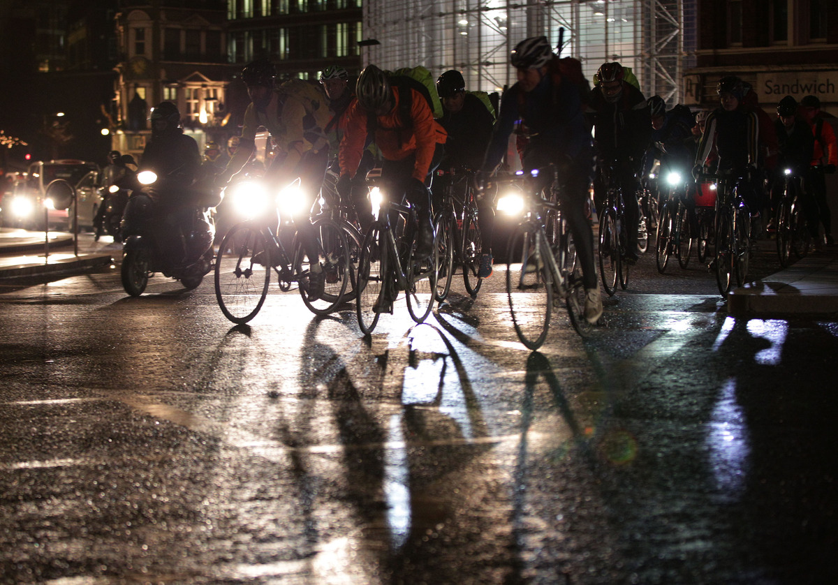
Image courtesy HuffingtonPost.com, which has a number of Tube Strike photos
Regular media and social media are abuzz with ‘Why you really don’t want to be a Londoner right now’ and ‘Top ten worst images from the London Tube strike.’ And its true its caused a little bit of hysteria: the London Underground is running a skeleton service Wednesday and Thursday (scheduled to end in a few hours) to protest staffing changes, including closing ticket offices (possibly to turn them into Amazon or grocery pick-up facilities, which I think sounds kind of awesome). The Tube workers say that the move will make the Tube less hospitable to elderly, disabled and female riders; I did see a Tweet from a disabled-advocacy group so there must be something that I’m missing.
Anyway. The strike is the first of 2 scheduled walk-outs in protest of the changes, and has resulted in a fair amount of chaos around the city, with bus queues stretching down streets and YouTube videos of arterial roads turned into parking lots.
That said, there was far less chaos than I was expecting. In my two days of commuting around London (one in heavy rain – awesome!), there were noticeably more people on foot. And larger were noticeably more aggressive – I saw a white van almost take out a woman my mother’s age on a left turn this morning. It was so egregious I tried to note down the plate, only to be enraged at the next street when a Royal Mail van did almost exactly the same thing. That said, motorized traffic through the city centre did not seem substantially worse than normal. And while there were loads of pedestrians around King’s Cross and around UCL, that’s pretty much standard, as well. In general, the most common comment I’ve seen on Facebook in response to ‘look at these crazy crowds!’ is ‘looks about normal to me.’
There have been noticeably more cyclists, though. Use of the cycle hire scheme is up 50% (with staffing to match) and there was a noticeable uptick in novice cyclists, both on personal and cycle-hire bikes, tooling around the city. Not only were they novices, they were jerks: lots more cycling on the sidewalk (or pavements, as they’re called here) and the wrong way down one-ways. There were also a number of efforts to encourage safe cycling, the most notable being the #bikethestrike campaign on Twitter, where regular commuters publicised their routes and led ‘rusty riders’ home like ducklings. Some of my coworkers have said they wish such a service existed all the time, so I’m hopeful that despite today’s awful weather, some of the cyclists will stick.
On the whole, I think efforts like #bikethestrike and seasoned cyclists’ desire to publicise the benefits have led to really lovely behavior. I had a nice chat with a man yesterday where I showed him how to work the machines and wished him well in his new job (it was his first day. Poor bastard.) Later, when I inadvertently cut off a lycra-clad, lithe young man in an expensive helmet, I turned around to apologise, and he said ‘no worries, I liked the look of you.’ While my initial reaction was ‘STILL GOT IT!” I realise now he was probably not flirting with me, after all. Of course, moments later, as I was cycling down Tavistock Road reflecting on how lovely people can be, a pedestrian stepped in front of a cyclist, who snarled ‘get out of the fucking way!’
Not that it excuses his behavior, but he totally had the right-of-way and the walked was behaving really dangerously by stepping in front of about a dozen cyclists, all accelerating to make it through the light.
While I think the Tube strike was unwarranted, and that ticket offices probably are outdated and expensive to maintain, I also think that things more or less went okay, given my expectations. If you were stuck in a car, I have no sympathy for you. And if some more people cycled…that’s great. The Tube transports about 4 million people every day, so I don’t want to suggest that it isn’t an important means of transport. Clearly, it’s one of the world’s great urban transpo networks. But the city didn’t grind to a halt without it – people walked, rode bikes, and found ways around it, and that’s what they (we) will do again in the event of another strike next week.
Christchurch, NZ and Jan Gehl
I was lucky enough to go to the Hackney Empire last week, a fantastic 1901 theatre slightly off the beaten path (we had to take the Overground to get there – well outside my usual stomping grounds). We were there for a screening of the film ‘The Human Scale,’ a documentary about the work of Jan Gehl and the way he has worked to make cities all over the world more geared toward people and less geared toward cars and high rises. His most famous book is called ‘Cities for People’ and he is to urban planning what David Attenborough is to nature documentaries, so I was super, super psyched to get to see the film and to hear the Q&A with him afterward, and the whole evening totally lived up to my expectations.
One of the major tenets of Gehl’s work is borrowed directly from traffic engineering: it is a truism in urban planning that more roads does not ease congestion; it only encourages more driving. But, it turns out, it holds for public space as well: creating more public space creates more use of public space. This has been most recently demonstrated by the changes that Jeanette Sadik-Khan has made to the New York City street grid (pedestrianizing Times Square in 2009 being the platonic example). Man, do I wish I’d thought of that.
The film (which is 90 minutes, but we saw an abbreviated 60 minute version) focuses on 5 tenets of Gehl’s work, and chooses a case study (or in some cases 2) to illustrate the ways in which Gehl’s work has been applied and to what effect. For the most part I thought it was amazing; there was a section on high-rise suburbs in China; on traffic engineering in New York City, on pedestrianization in Copenhagen; in urban interventions in Melbourne; and a final section on the rebuilding of Christchurch, New Zealand. Gehl gave a short presentation on London, as well.
I’ve spent a fair amount of time in New York but none in China, Copenhagen or Melbourne. However, I did spend two very full days exploring Christchurch about a year ago. The city was devastated by a series of earthquakes in 2011-2012 that hit the downtown area especially hard – so much so that as of a year ago, a huge section of the city was still completely fenced off, completely inaccessible unless you were part of the demolition crew. In the initial rebuilding, the city moved to minimise parking and to restrict buildings to 6 stories, which a feasibility study suggested was most appropriate to Christchurch conditions – above 6 stories, buildings need stronger foundations and reinforcements that render extra stories less lucrative than is commonly imagined. Gehl Architects were called in to help the city envision its future and to create a redevelopment plan that respected the human scale and restored the city’s quality of life, though responsibility for the plan was subsequently taken away from the city government. And when I was there in March 2013, there were giant boards advertising the city’s bold plan of action.
It did not live up to my hopes and dreams.
The film made it clear that the outcome of the planning process was not everything Gehl Architects (not to mention Christchurch city planners) had hoped. And the scale of the disaster is something that’s hard to comprehend from a documentary film. Christchurch faces an uphill battle, even with Gehl Architects’ advice: New Zealand, as much as many parts of the US, is a car-dominated city (712 cars per 1000 people, vs. 828 in the US). A map of Christchurch is almost funny – even the most novice mapreader will be able to tell where the master-planned portion of the city ends:

What were the original boundaries?
Like many colonial cities, Christchurch was founded on the site of a Maori settlement in the mid-19th century. The streets reflect the city’s origin and subsequent expansion, which is to say: they are really, really wide. In the US, midwestern cities (the same vintage as Christchurch) were built wide to accommodate streetcars and today are being retrofitted with bike lanes (and, in my hometown’s case, they’re resurrecting the streetcars. Woot!). I’m sure this is something that Gehl & Co. took into account when they actually made their recommendations to the city. But a few things struck me as I walked around, none of which were addressed by the masterplan the city ultimately ended up with or in ‘The Human Scale:’
1. The city is car-dominated. There are some lovely, quiet residential streets and a big park and some reasonably pleasant stuff, but the routes between them are dominated by wide avenues full of fast-moving traffic. While some early recovery projects have sought to address this, there was not a city-wide effort to address the ratio of pedestrian to car space.
2. The pace of rebuilding is frenetic, even with a big chunk of the city centre fenced off and still being demolished. Everywhere you go, you see billboards advertising new construction. The use, heights, scale and design quality of the buildings varied considerably.
3. The city masterplan is published and hanging on big boards outside the cathedral (which is fenced off, but as a major tourist attraction, has a special access point that allows yahoos like me to get a good view). The masterplan focuses on a series of mega-projects, like a new healthcare centre and a new conference facility, at the expense of the parts of the city people actually live in. I thought the future city outlined outside the cathedral represented a huge missed opportunity, and I will be detailing my logic in successive posts.
In the meantime, please note that my experience of the city is already outdated, as is ‘The Human Scale,’ both of which are from 2013. If there have been developments that I have missed, please let me know.
A friend recently told me that, with the birth of their second child looming, they’re looking at minivans. Thankfully, she told me via email so she couldn’t see the look that flashed across my face. Upon reflection, I can see why a minivan makes sense for her lifestyle. But I have also spent the last few days feeling more smug than ever that a minivan isn’t in my future.
Obviously, this has meant exchanges: less house for more neighbourhood, fewer comforts (like a clothes dryer…) for more ‘character’; and less car for more bikes. In our case, my husband and I have let our grace period lapse and are now no longer eligible for UK insurance, so we’ve settled into an entirely car-free lifestyle without even intending to. We live in a walking neighbourhood in a biking city, near a commercial street that caters to most of our needs (fruit, chocolate, and sushi) and near local retail that caters to the rest (pastries, pubs, dumplings).
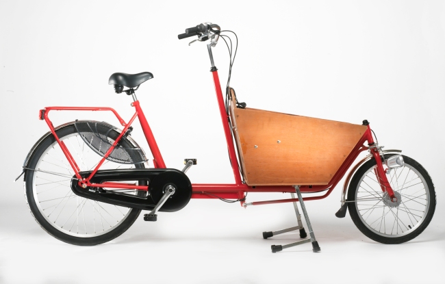
We’ve spent our first two+ years here cycling, but our mobility is going to be seriously curtailed with the birth of our first child this spring. Newborns don’t ride bikes, and typically, neither do their mums. When I was in Denmark earlier this year, I saw an amazing cargo bike with bassinet and OH DANG DID I WANT ONE. In fact, I’ve always assumed that when the time came, I’d buy a cargo bike – obviously.
So why am I telling you this, rather than raving about my sweet new cargo bike?
How much do you think they cost?
No, seriously. Think of a specific number.
The bikes I have seen – via Google – tend to run about £2500, or $4000; the cheapest model I’ve seen is £1710. There is also a bizarrely anaemic resale market (though if you’re looking, Ebay seems to be your best bet). I’ve had my current road bike for a decade, but I can’t imagine that I’ll want a cargo bike after my children are old enough to cycle on their own steam – say, when they turn five or six. And these bikes are really the most useful when you have two children – when you have one, there are simpler, easier methods; when you have an older one, why would you ferry them around when they can power themselves? So the window of time in which cargo bikes are truly useful is very small – higher if you have twins, but five or six years at the outside.
I do not understand why these things are so expensive. Over the course of their lifetimes, they are more cost-effective than a car, of course, but the up-front cost is nearly the same (or at least, for $4000 you can buy a car. A car with a roof and a trunk and a gas pedal that requires no physical exertion to use). I am one of the most enthusiastic and committed cyclists I know, and if I’m balking…who are the people buying these things?
There are, of course, cheaper alternatives for those interested in cycling with kids. The Guardian Bike Blog did a lovely feature last summer about the various options for carting children around via bicycle, from age 9 months to 9 years (I tried to figure out how to embed the video and failed). Plenty of parents have carried children around on standard rear-mounted bike seats or in those pull-behind trailers, which are much more affordable alternatives. But it seems to me that the economics of cargo bikes are completely misaligned. If I could find a cheaper bike – especially new – I would snap it up tomorrow, and I suspect many of the people I know in my position would, as well. Obviously cargo bikes are a commodity, so this isn’t something that can be fixed by government policy. And there is a chicken-and-egg issue: without more demand, carriers are unlikely to diversify their supply. But I do wonder why the market, even in places where cycling is an established way of life, has been so slow to address the need for family-friendly cycling. And given that there is so little to do except wait for the market to catch up, what can cycling advocates and government-provided infrastructure do to help bridge the gap?
Cambridge has a unique policy where parents of young children can exchange their bicycle for a stroller/buggy at a city-run cycle parking facility, though its not well-publicised (and people are crazy snobby about strollers). Maybe providing cargo-bike specific parking would help; so would wider, or – better yet – segregated bike lanes, though Cambridge already has quite a few off-road cycle paths. The general wisdom in the cycling world is that if you make everything about cycling better, you will attract more women and parents of young children, which is undoubtedly true. But there’s been a major uptick in cycling in the last several years without a commensurate increase in cargo bike use, so I’m inclined to think that someone is missing a trick.
Bikes, Children, Parents: Navigating the City with Babies
How do you see the world?
If you ask a collection of strangers to draw a world map from memory what do you get? With an understanding of map projections, we know there is no one “correct” depiction of the globe on a flat piece of paper. But do people even get close?
Zak Ziebell undertook such a project and asked 30 people on the University of Michigan campus to draw the world map from memory. He then combined the layers in Photoshop to produce one map as seen below. One vision of the world from the University of Michigan.

The resulting map, in my eyes, is not bad. New Zealand and England are forgotten, Greenland becomes part of North America, and the Middle East and India smush together to form some sort of African/Asian hybrid. So it’s not great either. Is this a sign of American Geographic Illiteracy as some of the online overseas community has suggested? Or is it a sign of hurried impatience as a stranger approached a map drawer en route to more pressing matters?
I would love to see a similar project undertaken by people at all corners of the world; or even all corners of America. I would love to see it undertaken without a political bent. If somehow time of drawing could be controlled. Would it result in an illustration of American incompetence or American impatience? Or both? Or Neither?
I probably would forget New Zealand too. But would they forget the Great Lakes?
Smoking is the Worst Thing Ever and Smokers Should be Ashamed of the Costs They Impose on Society
I’m hoping that my co-blogger will write a counter-p0int to this post, so I’m keeping the title just the way it is.
Because in our family, there is a schism (or maybe just a spectrum): my mother smokes. My sister isn’t bothered by smoking. My father finds it unpleasant.
And I find it completely unacceptable behavior, and cannot believe that the Western world has continued to allow smoking to occur. The notion that smoking is legal actually boggles my mind. And I do not remember a time when I didn’t think smoking was disgusting. As desperately as I wanted to be popular in middle and high school, as much as I was surrounded by cigarettes in college, and as much as I envied the architects (already wayyyy cooler than the urban planners) in grad school when they made an intimate cabal under the pillars, I have never considered smoking.
So all that said, I have become even more militant about smoking. At (SO CLOSE TO) seven months pregnant, I have become an anti-smoking vigilante, going so far as to involuntarily screech at someone yesterday when they blew smoke in my face from their bicycle. It was a reflex, I swear. I stomp behind smokers as I walk to work in the morning and I take a lot of pleasure in farting as I pass smokers (at socloseto seven months pregnant, I can more or less fart on command). They probably can’t smell it but I like to think I’m sticking it to’em, nonetheless.
All of this is a prelude to saying: I think smoking is an urban planning issue. A public health issue, too, but also something that raises fundamental questions about the way we allocate public and private space, and how we direct public resources (for example: in the Luxembourg Gardens in Paris, there are hordes of employees tidying the cigarette butts from the meticulously maintained gravel.) And the move to outlaw smoking indoors reflects the fact that, while my opinions are more vehement than most, there is general acceptance of the notion that people who smoke impose a cost on those who don’t. And as smokers are increasingly concentrated in public space, they are increasingly imposing a cost on others who want to use that public space.
On the one hand, all of this is increasingly rendered irrelevant as the number of smokers decreases: in California, the percentage of smokers is only 12%, and in the US as a whole, it is down to 18.6%, which is significant because conventional wisdom has been that 20% of people are ‘hardcore’ smokers who cannot be persuaded to quit (according to The New York Times). In the UK, the percentage of smokers was 39% in 1979, but has dropped to 21% today (says Wikipedia). One could argue that my whole rant is moot: smokers are already a marginalised population, right?
I don’t think so. If you smoke, you are not bothered by other people smoking (I assume), even though you are still exposed to the risks of secondhand smoke…and firsthand smoke… But as the population of non-smokers increases, the amount of people who are unfairly exposed to secondhand smoke, who would really like to have a relatively carcinogen-free walk to work, increases. The relative cost that a single smoker imposes on everyone else increases.
In the US, cities around the country have adopted measures to restrict public tobacco consumption. In New York City, a 2011 law means smoking in public parks can result in a $50 fine. Boston Common is smoke-free. Burlington, Vermont has adopted a law requiring all public places to be smoke-free (though not necessarily public streets). And Boulder, Colorado is currently weighing a proposal to make all public space, including cars parked in public space, smoke-free. This is ironic given that the same state decriminalised marijuana about five minutes ago. In the UK, smoking is illegal in pubs and transit hubs, but ‘Please do not smoke here’ signs are roundly and gleefully ignored. Cigarettes are actually cheaper here, and loose tobacco and rolling papers are widely available and much more popular than in the states.
While smoking is decreasing, I don’t think any municipality (save for Boulder – go Boulder) is doing enough to curb smoking. There are a number of things both countries, and any governments (city, county, state) within those countries could do to reduce the prevalence of smoking. Some proposals include:
1. Regulate vapor cigarettes and then make them widely available and subsidised. The idea that they are a ‘gateway drug’ is preposterous and makes me kind of stabby. How many people took up smoking after they just couldn’t get enough of Nicorette? Zero.
2. Tax the crap out of cigarettes. They’re $12 in New York, but I’d be happier if they were $15. Or $20! why not? In the UK, a box of cigarettes is about £7 (which equals about $10.80). This is the only consumer good I can think of that costs less in the UK than it does in the US. For real.
3. Sell cigarettes in a variety of increments. A friend of mine who is trying to quit smoking recently pointed out that though he is down to 2 cigarettes a day (go, friend!), he still buys 20 at a time. And if he buys 20, he’ll smoke 20. In England you can buy them in packs of 10, and I think there are some brands in the US that sell half-packs. But the act of buying things makes you more aware of your consumption, and makes people more aware of how much they’re spending on cigarettes.
4. A halfway policy: make littering cigarette detritus illegal. No more flicking cigarette butts! Someone once said to me, ‘if I lit up a piece of paper and dropped it in the street, that would not be regarded as acceptable.’ But that’s exactly what smokers do, hundreds of thousands of times a day every day (except my mom. she doesn’t do that. Thanks, mom). Littering is not allowed. Let’s start there.
5. Make smoking in public places a fine-able offence. I don’t think smoking should be illegal; I think tobacco and marijuana should both be legal and regulated and expensive and commercially available.
On the other side of the coin, let’s please get rid of DARE and other education programs that have never worked, ever, and use that money elsewhere. Let’s make faux-smoking easier to do, and let’s allow THAT in public places (assuming there’s no health risk to everyone else). And let’s use the money from all the fines I just proposed for a public-health bonanza – I don’t know what that would look like, but I would vote for public transit investments and infrastructure to address food deserts, and possibly health care to marginalised people, who are the most likely to smoke (hell, I would too). I don’t want to criminalize smoking; I just don’t think I should have to be faced with secondhand smoke, and nor should anyone else who doesn’t want to be.
I’d Live There: Park Slope, Brooklyn
That’s right, its the return of I’d Live There, where Izzy and I talk about real estate we can’t afford, often in places we don’t live. Real estate has been a frequent topic of conversation with us lately, because she’s looking for a new place, my husband wants to buy a house, and friends are looking in New York. Naturally its the place in New York that has already sold that appeals to me the most. It’s in an old clock factory! And those bookshelves along the staircase just kill me.

I also like the Eames chairs.

The images come from Streeteasy.com.
I want to go to there.
Pruitt Igoe Miscellany

Image courtesy google maps.
I’ve been meaning to write this post for a long time. 2012 was the 40th anniversary of the destruction of the Pruitt-Igoe housing development in St Louis, Missouri – one of the most iconic public housing ventures of all time; March 2013 marks the 41st anniversary. The land where the buildings stood is still vacant, with a fence around it; 57 acres of urban wilderness in the most literal sense.
In recent years, the site has received a lot of attention – most notably, in the form of Pruitt Igoe Now, a documentary released in 2011. A design competition, soliciting suggestions for what to do with the site, was conducted in 2012 – the winning submissions are viewable on the website; predictably, many focused on urban ag or forestry, though the diversity achieved within the theme is pretty impressive. And the mostly-excellent design podcast 99% Invisible did a piece on Pruitt Igoe for their 44th episode, though most of their content was derived from the film.

Image courtesy Pruitt Igoe Now design competition – from ‘Connections,’ a finalist in the competition
There are obviously all sorts of reasons why the housing project failed, and architecture is part of it – similar towers have failed elsewhere; Pruitt Igoe is simply the most iconic. But the film works hard to couch the development’s demise in the larger context of post-war St. Louis, and if you look at the image above, you can get a sense of the devastation experienced by adjacent areas that weren’t leveled. By my count, the twenty blocks north of the development have twenty houses on them. It is easy to fetishize Pruitt Igoe, but doing so completely ignores the huge swathes of adjacent land that are almost as devastated – and they didn’t have a huge, iconic explosion to help them get that way.
What is to be done with cities like St. Louis, where large chunks of the urban area are essentially ghost towns? Suggestions that the area be allowed to return to nature, that the remaining citizens be relocated, is typically not politically achievable. On the other hand, neither is it economically feasible to provide urban services to places that have one home per city block, usually with diminishing tax revenue. In New Orleans, the post-Katrina ‘green dot’ map of unviable neighbourhoods provoked a shitstorm of protest from local residents, who in many cases rebuilt with a vengeance in places that should never have been built on in the first place – but that’s a rant for another time. I’ve written before about neighbourhoods on the cusp, like the Near North Side of Pittsburgh, and I won’t rehash that post anymore here. Whatever solutions we do come up with for shrinking cities, the testing grounds shouldn’t be limited to the Pruitt Igoe site; while it is absolutely a good idea to invest in the large scale ecological regeneration of St. Louis, and there is symbolic value to starting with the Pruitt Igoe site, it’s now a 40 year old urban forest and it has value unto itself. Its not like there’s no other land to work with; maybe just leave well enough alone until such time, if ever, when there’s a reason to redevelop.
And in the meantime, check out the film, podcast, Economist article, MIT studio, and book chapter on St Louis in particular and shrinking cities in general. If you have resources or thoughts on Pruitt Igoe, St. Louis or shrinking cities, please let me know.
Shuttle Challenge
The Shuttle Challenge is a reward-based initiative that challenges commuters to drive 10% less. Once every two weeks, it encourages you to take a non-car method of transportation – public transit, walking, or biking. It highlights how small changes in transit patterns could make a huge difference in green house gas emissions.
Just by participating you are offered a reward. When I heard this, I thought “Great! Encourage people to participate!” Then I read that the rewards were gas cards. GAS CARDS? Seems a little counter intuitive.
It must be to them as well – because front and centre on the front page of the website is this Q&A.
Q – Why is an environmental organization giving away free gas?
A – To motivate you to take action. Summerhill impact challenges you to drive better and drive less.
That doesn’t seem like a clear answer to me. They go on to elaborate here. The further explanation boils down to 3 points –
- Canadians are going to drive a lot anyway
- Canadians love cheap gas
- We may as well try something new because what we have tried thus far to get people to drive less hasn’t worked.
I’m not sold. Not yet at least.
Check out the website and make your own opinion at http://www.shuttlechallenge.ca.
